|  |
| Larger Image (37.6 KB) |
| PARO Acc. 3466/HF 77.239 |
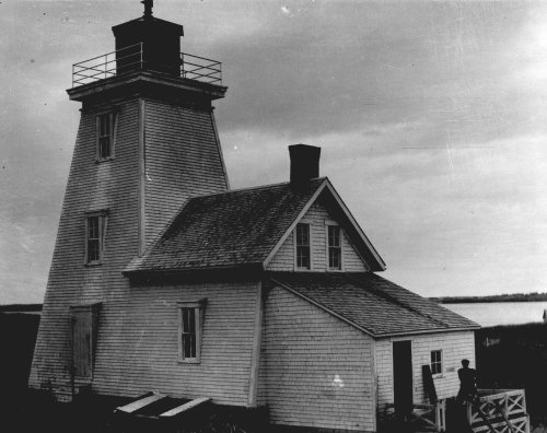
| Fish Island Lighthouse, 1913 |
| |
| Between Malpeque Bay and the Gulf of St. Lawrence lies Fish Island. Samuel Holland called it Billhook Sand in 1765 and noted that the fishery was located there. A Fish Island lighthouse has been operating since at least 1879. Belcher's Farmers' Almanac would have been an indispensable guide for mariners as they list very specifically the location, ranges and colours of lighthouses, buoys and fog alarms signals in the region. The 1919 Almanac warns mariners of sand bars and the possibility of sand blocked channels at the entrances of many Prince Edward Island north shore harbours. Ranges of lights leading into harbours could be changed without special notice -- mariners were advised not to cross the sand bars without local assistance. | | Next>>> |
|
| Return to Exhibit Listings |
|
| To see more of the images from this and other collections visit the Public Archives and Records Office, Atlantic Technology Centre (ATC), 176 Great George Street, Suite L20, in Charlottetown, Prince Edward Island. | For more information about the Public Archives and its holdings, please visit princeedwardisland.ca/en/topic/libraries-and-archives.
|
|


