
PlaceFinder


HOME /
Central Bedeque, a village, is located in Prince County in the western portion of Prince Edward Island, N. of Borden. Its precise location is N 46°20', W 63°42'.
This page is a comprehensive index of all of the information on our website related to Central Bedeque. You can also search for information on other communities.
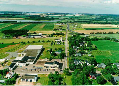
| Aerial Photographs |
Aerial photography courtesy of AirScapes. All aerial photographs are available for sale, as prints or slides; please contact AirScapes for details. You can also see a complete list of aerial photographs of the Island.
 | Central Bedeque 701 x 508 - 60K 500 x 362 - 64K |
| Visitors Guide Listings |
Our Visitors Guide is a complete vacation planning manual.
| The Geography of Central Bedeque |
Maps
You can use our interactive maps to
display maps of Central Bedeque and area.
Click on the map link:
Show Map
| Statistical Information |
The PEI Community Accounts has information about Central Bedeque. Community Accounts provides a comprensive source of community, regional, and provincial data on social, environmental and economic topics
Information courtesy of Community Accounts
Central Bedeque falls inside the Statistics Canada
census subdivision of Lot 26. They have detailed statistical information available
for the Lot 26 census subdivision for the following categories:
Education,Ethnicity,Family,Income,Labour Force,Population, and Shelter.
Information courtesy Statistics Canada.
| History of the Name |
The official history of the geographic name Central Bedeque (which can be somewhat technical, we admit):
The Community of Central Bedeque was incorporated in 1966. Contains the Locality of Central Bedeque.
Information courtesy Geomatics Canada .