
PlaceFinder


HOME /
Cherry Valley, an unincorporated area, is located in Queens County in the central portion of Prince Edward Island, E. of Charlottetown. Its precise location is N 46°10', W 62°55'.
This page is a comprehensive index of all of the information on our website related to Cherry Valley. You can also search for information on other communities.
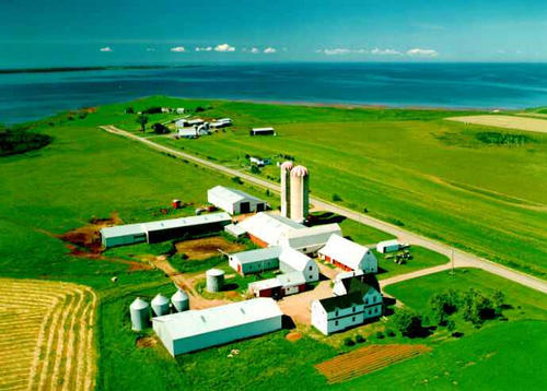
| Aerial Photographs |
Aerial photography courtesy of AirScapes. All aerial photographs are available for sale, as prints or slides; please contact AirScapes for details. You can also see a complete list of aerial photographs of the Island.
 | Farm 691 x 495 - 33K 500 x 358 - 44K |
| Visitors Guide Listings |
Our Visitors Guide is a complete vacation planning manual.
| The Geography of Cherry Valley |
Maps
You can use our interactive maps to
display maps of Cherry Valley and area.
Click on the map link:
Show Map
| Statistical Information |
Cherry Valley falls inside the Statistics Canada
census subdivision of Lot 50. They have detailed statistical information available
for the Lot 50 census subdivision for the following categories:
Education,Ethnicity,Family,Income,Labour Force,Population, and Shelter.
Information courtesy Statistics Canada.
| History of the Name |
The official history of the geographic name Cherry Valley (which can be somewhat technical, we admit):
The name applies to the settlement along the road from the former location to an d including Cherry Valley South. Cherry Valley (Sett., P.O.) was adopted in Plac e Names of PEI, 1925.Confirmed 6 May 1947 on c. 4405 at 46 11 - 62 56.Applic ation altered 17 January 1972 on 11L/2 to 46 10 - 62 55.Status changed to Loca lity 23 October 1989on 203-8. Joseph Beers renamed Marguerite to Cherry Valley - PN of PEI, 1925.
Information courtesy Geomatics Canada .