
PlaceFinder


HOME /
Judes Point, an unincorporated area, is located in Prince County in the western portion of Prince Edward Island, E. of Tignish. Its precise location is N 46°57', W 64°00'.
This page is a comprehensive index of all of the information on our website related to Judes Point. You can also search for information on other communities.
| Aerial Photographs |
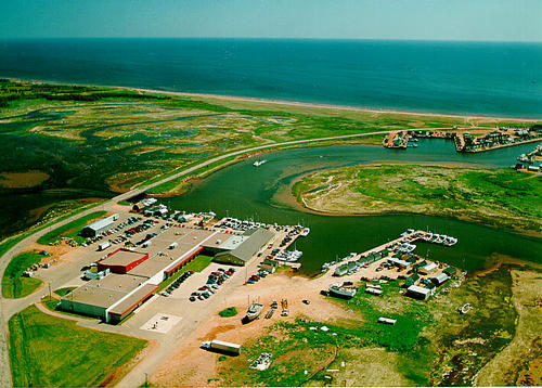
Aerial photography courtesy of AirScapes. All aerial photographs are available for sale, as prints or slides; please contact AirScapes for details. You can also see a complete list of aerial photographs of the Island.
 | Tignish Run 500 x 358 - 49K 711 x 510 - 110K |  | Royal Star Foods 500 x 358 - 64K 711 x 510 - 142K |
 | Tignish Run 500 x 358 - 60K 711 x 510 - 137K |
| Visitors Guide Listings |
Our Visitors Guide is a complete vacation planning manual.
| The Geography of Judes Point |
Maps
You can use our interactive maps to
display maps of Judes Point and area.
Click on the map link:
Show Map
| Statistical Information |
Judes Point falls inside the Statistics Canada
census subdivision of Lot 1. They have detailed statistical information available
for the Lot 1 census subdivision for the following categories:
Education,Ethnicity,Family,Income,Labour Force,Population, and Shelter.
Information courtesy Statistics Canada.
| History of the Name |
The official history of the geographic name Judes Point (which can be somewhat technical, we admit):
Judes Point (Loc.) was adopted 5 Deember 1966 on 21I/16.Confirmed 23 October 1 989 on 203.
Information courtesy Geomatics Canada .